| S.N | Mode | Route | Elev.(m) | Duration | Overnight | Included |
|---|---|---|---|---|---|---|
| 1 | Flight | Arrival Kathmandu Tribhuvan Int'l Airport - Tranfer Hotel | 1300 | Hotel | Dinner | |
| 2 | Tour | Swoyambhunath - Kathmandu Durbar Square - Preparatoin Sarebung Peak | Hotel | Breakfast | ||
| 3 | Drive | Kathmandu Hotel - Pirthivi High-Way - Pokhara Lakeside | 940 | 6/7 Hours | Hotel | Breakfast |
| 4 | Drive | Pokhara Lakeside - Beni - Tatopani - Marpha - Jomsom - Kagbeni | 2840 | 6/7 Hours | Guest House | Breakfast-Lunch-Dinner |
| 5 | Trek | Kagbeni - Kaligandaki River - Tangbe - Chhusang - Chele | 3050 | 5/6 Hours | Guest House | Breakfast-Lunch-Dinner |
| 6 | Trek | Chele - Taklam Pass - Samar - Yamda-La Pass - Bhena - Syanbocheen | 3800 | 6/7 Hours | Guest House | Breakfast-Lunch-Dinner |
| 7 | Trek | Syangbochen - Nyi La Pass - Ghami | 3520 | 5/6 Hours | Guest House | Breakfast-Lunch-Dinner |
| 8 | Trek | Ghami - Longest Mani Wall - Tsarang-La Pass - Tsarang (Charang) | 3620 | 5/6 Hours | Guest House | Breakfast-Lunch-Dinner |
| 9 | Trek | Tsarang (Charang) - Lo La Pass - Lo Manthang | 3840 | 4/5 Hours | Guest House | Breakfast-Lunch-Dinner |
| 10 | Drive | Exploring - History - Lo Manthang - Tibet Border | 3840 | 5/6 Hours | Guest House | Breakfast-Lunch-Dinner |
| 11 | Trek | Lo Manthang - Dhi Village - Kali Gandaki River - Yara | 3650 | 6/7 Hours | Guest House | Breakfast-Lunch-Dinner |
| 12 | Trek | Yara - Luri River Valley - Luri Cave Monastery | 4005 | 3/4 Hours | Guest House | Breakfast-Lunch-Dinner |
| 13 | Trek | Luri Cave Monastery - Duyung Khola - Chungsi La Pass - Ghuma Thanti | 4800 | 6/7 Hours | Guest House | Breakfast-Lunch-Dinner |
| 14 | Trek | Ghuma Thanti - Bachu-La Pass - Damodar Kunda - Namta Khola | 4890 | 6/7 Hours | Camping Tent | Breakfast-Lunch-Dinner |
| 15 | Trek | Namta Khola - Glacial Valley - Saribung Base Camp | 4950 | 6/7 Hours | Camping Tent | Breakfast-Lunch-Dinner |
| 16 | Rest | Rest & Acclimatization - Saribung Base Camp | Camping Tent | Breakfast-Lunch-Dinner | ||
| 17 | Trek | Saribung Base Camp - Saribung Camp I | 5700 | 4/5 Hours | Camping Tent | Breakfast-Lunch-Dinner |
| 18 | Climbing | Saribung Camp I - Summit Saribung Peak - Sarbung Base Camp | 6328 | 10/11 Hours | Camping Tent | Breakfast-Lunch-Dinner |
| 19 | Free | Reserve - Day - Saribung Base Camp | 4950 | Camping Tent | Breakfast-Lunch-Dinner | |
| 20 | Trek/Pass | Saribung Base Camp - Saribung Pass - Nagoru | 4400 | 7/9 Hours | Camping Tent | Breakfast-Lunch-Dinner |
| 21 | Trek | Nagoru - Nar-Phu Valley - Phu Khola - Phu Gaon | 4080 | 5/6 Hours | Guest House | Breakfast-Lunch-Dinner |
| 22 | Trek | Phu Gaon - Nar-Phu Valley - Kyang - Meta | 3560 | 6/7 Hours | Guest House | Breakfast-Lunch-Dinner |
| 23 | Trek | Meta - Nar-Phu Valley - Dharmasala - Koto | 2600 | 5/6 Hours | Guest House | Breakfast-Lunch-Dinner |
| 24 | Drive | Koto - Chame Village - Timan - Dharapani - Syange - Besisahar | 760 | 4/5 Hours | Guest House | Breakfast-Lunch-Dinner |
| 25 | Drive | Besisahar - Pirthivi Highway - Kathmandu - Farewell Dinner | 1300 | 5/6 Hours | Hotel | Breakfast-Lunch-Dinner |
| 26 | Flight | Departure - Kathmandu Tribhuvan Int'l Airport - Own Your Destination | Breakfast |
Upper Mustang trekking and Sarebung Peak (6,346m/20,815ft) Climbing is one of the most mysterious trekking with peak climbing in Nepal. It has been one of the popular and most loved trekking with peak climbing destinations in the country. Upper Mustang region lies in the western part of Nepal and is officially the name of the district having a Tibet like region. It is relatively easy trekking along the permitted route to Lo Manthang. It was open in October 1991. Mustang is situated on the head of Kali Gandaki River. The team of the Alliance Adventure has long been organizing Upper Mustang trek and Sarebung Peak Climb to the area and it is one of the authorized trekking agencies. Sarebung Peak climbing the trail through via Upper Mustang region thus it is the combined package of Upper Mustang trekking and Sarebung Peak climbing trails exist to Damodar Himal near to Damodar Kunda.
The Upper Mustang and Sarebung Peak climbing begins across the foothills of the Himalayas from Pokhara, whereby you can reach either by flight or bus from Kathmandu. The flight from you Pokhara to Jomsom, where Upper Mustang and Sarebung Peak climbing begins. The trail enter the spectacular Kali Gandaki river valley, the deepest gorge in the world. The mighty Kali Gandaki River passes between the mountains of Annapurna I and Dhaulagiri, both over 8000m. The Kali Gandaki valley was the main trading route with Tibet and the system of lodges and tea-houses here is well developed. Thakali ethnic people who inhabit in this area are renowned for their hospitality and for being obliging hosts and finally you will make excursion to the whole area and return to Besisahar then drive to Kathmandu.
 26 Days
1300 m.
26 Days
1300 m.
 Dinner
 Hotel
Hotel
Welcome! Upon your arrival at Kathmandu Tribhuvan International Airport, you'll be greeted warmly by our representative holding a sign with your name for easy identification. You'll be welcomed with a traditional Nepali culture by flower garland as a gesture of good will and blessing.
Our friendly team will assist you with your luggage and ensure a smooth transfer to your hotel in the heart of Kathmandu. Along the way, you'll get a glimpse of the city's vibrant streets, bustling with energy and charm.
Once at your hotel, you'll be helped with the check-in process. Afterward, you can relax and enjoy a refreshing welcome drink as you settle into the serene ambiance of your accommodation.
Before check in your room Alliance adventure will brief you about your activities with offering you nepali tranditional Dinner
26 Days
Breakfast
Hotel
Today half Day Sightseeing in Kathmandu World Heritage Site and Preparation your Upper Mustang Trekking and Sarebung Peak Climbing Gears. Alliance Adventure Tour Guide explore one of the most historical and spiritual attractions in Kathmandu’s Landmarks that are considered as World Heritage Sites; including the historic Durbar Square, the houses of living life Hindu goddess Kumari at “Kumari House’’. Swayambhunath; stands top of the top hill and west of the city, people mostly know as “Monkey Temple”. This has been registered in UNESCO heritage site. After lunch Alliance Adventure briefing you Upper Mustang Trek and Sarebung Peak Climbing, last minutes shopping if any missing your trekking and climbing gears and then packing to get readu your Adventure.
26 Days
940 m.
Breakfast
Hotel
Driving from Kathmandu to Pokhara Lakeside is one of the most popular journeys in Nepal, offering stunning landscapes, scenic views, and a glimpse of rural life along the way. The Prithvi Highway connects Kathmandu to Pokhara. While the road is mostly paved, sections may be narrow and winding. The journey follows the Trishuli River for much of the route, offering picturesque views of the river and surrounding hills and continues your journey you’ll arrive at Lakeside, the tourist hub of Pokhara, situated near the tranquil Phewa Lake.
26 Days
2840 m.
Breakfast-Lunch-Dinner
Guest House
The drive from Pokhara to Kagbeni around 160KM (100miles), located in the Mustang District of Nepal, is an adventurous and scenic journey. Marpha Village, often called the "Apple Capital of Nepal," is famous for its apple orchards, traditional Thakali culture, and serene beauty. The road is mix of paved and rough roads. You'll drive alongside the Kali Gandaki River, passing lush green hills, small villages, and terraced farmlands and stop at Tatopani, natural hot spring for couple hours and enjoy with nature hot spring bath and continues toward to Kagbeni is whitewashed houses, stone-paved alleys, and explore Kagbeni Monastery and explore the local Thakali culture.
26 Days
3050 m.
Breakfast-Lunch-Dinner
Guest House
The Trekking from Kagbeni (2,840m/9,318ft) to Chele (3,050m/10,006ft) is the first leg of the Upper Mustang trek. This is a scenic yet moderately challenging hike along the Kali Gandaki River and into the arid landscapes of Mustang. The trek following Kali Gandaki River on a sandy trail with occasional river crossings through Tangbe, a traditional village with whitewashed houses, apple orchards, and barley fields with Great views of Nilgiri Peak (7,061m/23,166ft). The flat sections, with red cliffs and caves on the valley walls to crossing Kali Gandaki River on a steel bridge near Chhusang (2,980m / 9,776ft) to Short but steep ascent to Chele. The first major Tibetan-influenced village, marking the entry into Upper Mustang. with views of dramatic rock formations and colorful cliffs.
26 Days
3800 m.
Breakfast-Lunch-Dinner
Guest House
The trek from Chele (3,050m/10,006ft) to Syangboche (3,800m/12,467ft) is a challenging yet rewarding segment of the Upper Mustang Trek. This section features steep ascents, deep gorges, and stunning views of the Himalayan desert landscape.
Chele → Samar (5km, 3,660m/12,007ft) Steep ascent from Chele to Taklam La Pass (3,624m/11,887ft). The trail features red and orange rock formations unique a beautiful Tibetan-style village with a few tea houses.
Samar → Bhena & Yamda La Pass (4 km, 3,850m/12,631ft) Descend into a gorge, then ascend to Bhena (3,850m/12,631ft). The Climb to Yamda La Pass (3,850m/12,631ft) for breathtaking views of snow-capped peaks passing by ancient caves and mani walls (prayer stone walls).
Bhena → Syangboche (1.5–2 hours, 3 km, 3,800m / 12,467ft), Gradual ascent through desert-like terrain and juniper trees and reaching Syangboche, a small village with Tibetan-style houses and a peaceful atmosphere with Amazing views of Nilgiri, Annapurna, and Dhaulagiri ranges.
26 Days
3520 m.
Breakfast-Lunch-Dinner
Guest House
The Upper Mustang trek is a challenging but rewarding journey through high-altitude passes, deep gorges, and remote Tibetan villages. The trek involves steep ascents and descents, offering spectacular views of the Mustang region and the Himalayas.
Syangboche → Nyi La Pass (4km, 4,020m/13,189ft). The trek begins with a gradual ascent through rocky and arid terrain passing by Chorten (Buddhist shrines) and prayer flags and steep climb to Nyi La Pass (4,020m/13,189ft), the highest point so far with panoramic views of Mustang’s barren landscapes and distant Himalayan peaks.
Nyi La Pass → Ghami (7km, 3,520m/11,549ft). The steep descent into the Ghami Khola (river) valley and the Ghami is the third-largest village in Mustang. The village is known for its whitewashed mud-brick houses, green barley fields, and ancient monasteries. Ghami’s iconic long Mani Wall—the longest in Nepal—decorated with Buddhist prayers and carvings.
26 Days
3620 m.
Breakfast-Lunch-Dinner
Guest House
Trek from Ghami to Tsarang (Charang) trek is one of the most scenic and culturally rich parts of the journey. You’ll pass through ancient Buddhist mani walls, high-altitude passes, and stunning barren landscapes before reaching the historic village of Tsarang (Charang).
Ghami → Longest Mani Wall (2km, 3,520m/11,549ft), the short descent to the Ghami Khola (river) and visit the longest Mani Wall in Nepal (~305m/1,000ft), decorated with Tibetan Buddhist prayers and inscriptions.
Mani Wall → Tsarang La Pass (5km, 3,870m/12,697ft), Gradual uphill climb on a dusty and rocky trail crossing the Tsarang La Pass (3,870m/12,697ft), offering stunning views of the barren Mustang landscapes and distant snow-capped peaks with strong winds are common in this area—start early!
Tsarang La Pass → Tsarang (4km, 3,620m/11,877ft), The walking descent into the Tsarang Valley, surrounded by cliffs and chortens and reaching at Tsarang (Charang, 3,620m/11,877ft), the second-largest village in Upper Mustang explore the Tsarang Monastery (400+ years old) and the ancient Tsarang Palace, once the seat of the Mustang kings.
26 Days
3840 m.
Breakfast-Lunch-Dinner
Guest House
Trek from Tsarang (Charang) to Lo Manthang, is one of the most exciting and iconic segments of the Upper Mustang Trek, as you finally reach Lo Manthang (3,840m/12,598ft), the walled capital of the ancient Kingdom of Mustang. The journey offers stunning views of Mustang’s arid landscapes, deep gorges, and Himalayan peaks, along with ancient monasteries and caves.
Tsarang → Lo La Pass (9km, 3,950m/12,959ft), the trail gradual ascent through barren terrain and dry riverbeds through Lo La Pass (3,950m/12,959ft), the final high pass before Lo Manthang of first panoramic view of Lo Manthang, surrounded by red cliffs, chortens, and the snow-capped Himalayas (Nilgiri, Annapurna, Bhrikuti, and more).
Lo La Pass → Lo Manthang (4km, 3,840m/12,598ft), walking gentle descent towards the walled city continues reaching at Lo Manthang, the ancient capital of Mustang, known for its white-walled fortress, monasteries, and Tibetan culture.
26 Days
3840 m.
Breakfast-Lunch-Dinner
Guest House
Exploring the History of Lo Manthang
Lo Manthang, the walled capital of the ancient Kingdom of Mustang, is one of Nepal’s most culturally rich and historically significant destinations. Founded in 1380 AD by King Ame Pal, this city remained an isolated, autonomous Tibetan kingdom until 2008, when Nepal abolished its monarchy. The region is famous for its Tibetan Buddhist heritage, ancient monasteries, and unique cave dwellings carved into cliffs.
Foundation and the Kingdom of Lo:
Lo Manthang was established as the capital of the Kingdom of Lo in 1380 AD. King Ame Pal is credited with unifying the region and building the walled city to protect against invasions. The Kingdom of Lo maintained its independence while having strong ties to Tibet, both culturally and politically.
The Role of the Lo Kings:
Lo Manthang was ruled by the Mustangi Kings (Lo Gyalpo) for over 600 years. The monarchy remained even after Nepal annexed Mustang in 1950, but it lost official status when Nepal became a republic in 2008. The last king, Jigme Dorje Palbar Bista, lived in Lo Manthang until his passing in 2016.
Cultural and Religious Significance:
Lo Manthang is home to some of the oldest and most sacred Tibetan Buddhist monasteries in Nepal - Jampa Gompa (built in the 15th century) – Also known as the "God House," it features ancient murals. Thubchen Monastery (built in the 15th century) – A massive red monastery with intricate artwork. Chode Gompa – The main monastery still in active use today. The city also has the Royal Palace, which housed the Mustang kings for centuries.
The Forbidden Kingdom and Opening to Tourists:
Mustang was a restricted area until 1992, meaning foreigners were not allowed to enter in 1992, Nepal opened Upper Mustang for limited tourism, requiring a special permit. This helped preserve its Tibetan culture, as the region was isolated from modernization.
Ancient Cave Dwellings and Hidden Artifacts:
Lo Manthang is surrounded by man-made cave dwellings that are over 2,000 years old. These caves, such as the Jhong Caves in Chhoser, were used as homes, meditation retreats, and burial sites. In 2007, archaeologists discovered ancient Buddhist murals, manuscripts, and mummies inside some of these caves.
Present-Day Exploration:
Today, Lo Manthang remains a UNESCO tentative site, known for its unique architecture, Buddhist traditions, and festivals like the Tiji Festival. Despite modern influences, it retains its medieval charm, with whitewashed mud-brick houses, chortens, and prayer wheels.
26 Days
3650 m.
Breakfast-Lunch-Dinner
Guest House
The trek from Lo Manthang to Yara (3,650m/11,975ft), is an exciting and off-the-beaten-path journey through the remote landscapes of Upper Mustang. This route takes you through barren cliffs, deep canyons, and ancient cave dwellings, offering a more rugged and less-traveled experience compared to the main Upper Mustang trail.
Lo Manthang → Dhi Village (3,410m/11,186ft). The trek starts with a gradual ascent leading to Dhi Pass (3,950m/12,959ft) with panoramic views of Mustang’s dramatic landscape and the Tibetan Plateau. The trail descent to Dhi village, a small settlement with traditional houses and green barley fields and Lunch break in Dhi before continuing to Yara. After lunch cross the Kali Gandaki River, which can be challenging depending on water levels. The trek through eroded cliffs, caves, and ancient chortens along a narrow trail reaching Yara, a quiet, isolated village with stunning rock formations and traditional Tibetan-style houses.
26 Days
4005 m.
Breakfast-Lunch-Dinner
Guest House
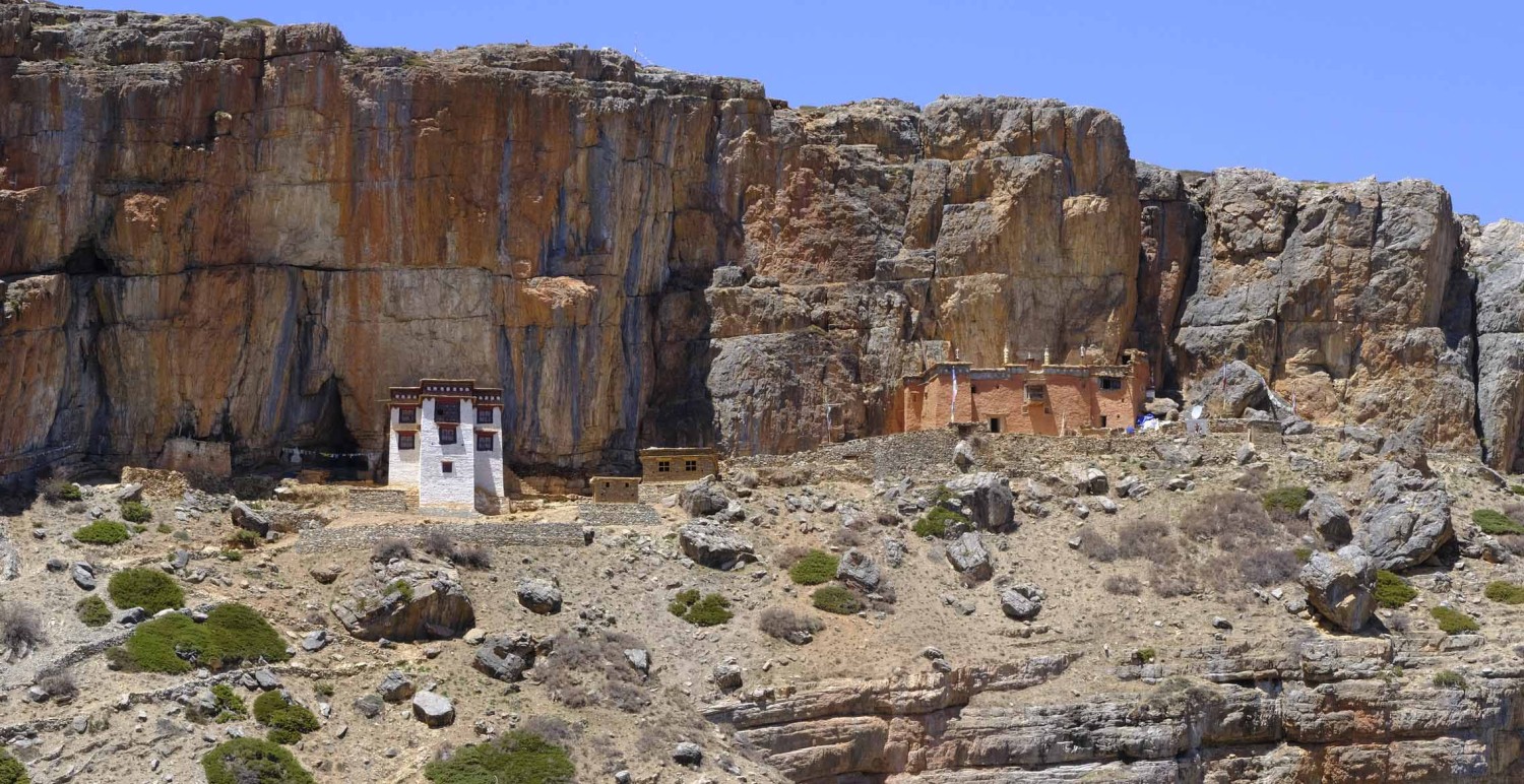
The trek from Yara to Luri Cave Monastery (4,005m/13,140ft), is a short but rewarding journey through Upper Mustang's remote landscapes, leading to one of the most mysterious Buddhist cave monasteries in Nepal. Luri Gompa (4,005m/13,140ft) is an ancient monastery carved into a dramatic cliff, dating back to the 14th century, and is famous for its stunning murals, hidden chortens, and Vajrayana Buddhist relics. The trail follows a narrow ridge and descends into a dry river valley walk along eroded cliffs and dramatic rock formations unique to Mustang’s desert landscape crossing a small wooden bridge over the seasonal Luri Khola (river). The trail gradual ascent through a rugged path leading to the monastery entrance. The final stretch requires a steep climb up a narrow trail to reach Luri Gompa with stunning panoramic views of Mustang’s barren landscapes and snow-capped peaks.
Exploring Luri Cave Monastery – The Hidden Treasure of Mustang
Luri Gompa (Luri Cave Monastery) is one of the most mysterious and sacred sites in Upper Mustang, Nepal. Dating back to the 14th century, this ancient Buddhist cave monastery is carved into a dramatic cliff at (4,005m/13,140ft) near Yara Village. It is famous for its intricate murals, hidden chortens, and ancient Buddhist relics, offering a glimpse into the Tibetan Buddhist heritage of Mustang.
26 Days
4800 m.
Breakfast-Lunch-Dinner
Guest House
The trek from Luri Cave Monastery to Ghuma Thanti (4,800m/15,748ft), is a remote and adventurous journey through Upper Mustang’s rugged terrain, high passes, and isolated landscapes. This less-traveled route takes you deeper into the hidden valleys of Mustang, offering breathtaking views of eroded cliffs, vast plateaus, and snow-capped peaks. The Luri Gompa following a narrow ridge and dry river valley crossing several small streams and eroded cliffs and reaching Duyung Khola riverbed, where you may spot wildlife like blue sheep. A steep and demanding climb leads to Chungsi-La Pass (5,000m/16,404ft) enjoy panoramic views of the Dhaulagiri, Annapurna, and Nilgiri ranges. The high altitude makes this section challenging—take it slow and stay hydrated. The gradual descent from the pass leads to Ghuma Thanti (4,800m/15,748ft). The landscape becomes more open, with rolling plateaus and small seasonal lakes. Ghuma Thanti is a remote seasonal yak herding settlement, with basic shelter for trekkers.
26 Days
4890 m.
Breakfast-Lunch-Dinner
Camping Tent
The trek from Ghuma Thanti to Namta Khola (4,890m / 16,043ft) is a remote and high-altitude journey through one of the least explored regions of Upper Mustang. This route takes you through barren highland plateaus, sacred lakes, and desolate mountain passes, offering a true wilderness experience. The steep ascent through high-altitude ridges and glacial valleys through Bachu-La Pass (5,300m/17,388ft), one of the highest points in Upper Mustang with pectacular views of Damodar Himal, Annapurna, and Dhaulagiri ranges and strong winds and thin air—take breaks to avoid altitude sickness. The short detour leads to Damodar Kunda (4,890m/16,043ft), a sacred lake in Hindu and Buddhist traditions, pilgrims believe bathing in the lake washes away sins. The lake is surrounded by barren, mystical landscapes with prayer flags fluttering in the wind. The trek gradual descent through dry, rugged terrain, trail becomes rocky and windswept, with stunning views of the Tibetan plateau continues Namta Khola, a remote campsite beside the river.
26 Days
4950 m.
Breakfast-Lunch-Dinner
Camping Tent
The trek from Namta Khola to Saribung Base Camp (4,950m/16,240ft) is one of the most challenging and remote high-altitude routes in Upper Mustang. This trek takes you through barren landscapes, glacier moraines, and rugged mountain passes, offering an unparalleled experience in the Himalayan wilderness. The trek a gradual ascent through a dry, rocky valley trail becomes steeper, with loose scree and moraines passing isolated glacier streams, with occasional blue sheep sightings and crossing a rugged glacial section, requiring careful footing on icy terrain the final ascent is challenging due to thin air and steep inclines continues to the Saribung Base Camp, offering breathtaking views of Saribung Peak (6,328m/20,761ft), Damodar Himal and Tibetan plateau.
26 Days
Breakfast-Lunch-Dinner
Camping Tent
Rest and Acclimatization at Saribung Base Camp is essential before attempting to cross Saribung Pass (6,042m/19,820ft) or attempting the Saribung Peak (6,328m/20,761ft) ascent. This rest helps your body adjust to the high altitude and reduces the risk of altitude sickness.
At elevations above 5,500m (18,000ft), the oxygen level is nearly 50% lower than at sea level, increasing the risk of Acute Mountain Sickness (AMS), High-Altitude Pulmonary Edema (HAPE), and High-Altitude Cerebral Edema (HACE).
26 Days
5700 m.
Breakfast-Lunch-Dinner
Camping Tent
The trek from Saribung Base Camp (4,950m) to Saribung Camp I (5,700m), is a crucial and challenging section of the Saribung Pass Expedition in the remote Upper Mustang region and Nar-Phu Valley Trek in Nepal. This part of the journey involves walking on rugged glacier terrain, navigating crevasses, and preparing for the demanding ascent toward Saribung Pass (6,042m).
26 Days
6328 m.
Breakfast-Lunch-Dinner
Camping Tent
Wake up around midnight 1 to 2AM, hot tea and breakfast and get ready to climb. The journey from Saribung Camp I to the summit the Saribung Peak (6,328m/20,761ft) and back to Saribung Base Camp is the most physically demanding and technically challenging part of the expedition. The Steep and exposed ridges, snowfields, and occasional ice patches. Alliance Adventure climbing guide leading a fixed ropes and following the guideline continues to the summit will spend 10–15 minutes enjoying the panoramic views of Annapurna Range and more snow mountain Peaks.
26 Days
4950 m.
Breakfast-Lunch-Dinner
Camping Tent
Reserve day at Saribung Base Camp (4,950m/16,240ft) is an essential buffer for summit attempts on Saribung Peak (6,328m/20,761ft). This day can be used for multiple purposes: waiting for better weather, further acclimatization, or resting to recover from fatigue. Summit day requires clear weather for safety and visibility. High winds, snowfall, or low visibility may delay the climb.
26 Days
4400 m.
Breakfast-Lunch-Dinner
Camping Tent
Trek from Saribung Base Camp (4,950m/16,240ft) to Saribung Pass (6,042m/19,820ft) and Nagoru (4,400m/14,435ft). This section of the Saribung Trek is one of the most challenging and rewarding segments, taking you from Saribung Base Camp over the high Saribung Pass and descending into the isolated region of Nagoru in the Nar-Phu Valley. The trek leading early in the morning at 3:00–4:00AM for stable snow conditions and steep ascent on glacier and ice fields, requiring crampons, ropes, and ice axes.
Navigate potential crevasses and icy slopes (30–40° inclination) continues top to the Saribung Pass (6,042m), marked by prayer flags and breathtaking views of Damodar Himal, Annapurna, and Mustang Himalayas with can be strong winds and freezing temperatures are common at the pass. The walking steep and technical descent on snow and loose rock trails and the trail is remote and isolated, with no settlements. trek through glacier moraines and rocky terrain towards Nagoru. As you descend below 5,000m, the landscape shifts to barren valleys with fewer snow patches. Nagoru is a small, seasonal yak grazing area in the Nar-Phu Valley, used as a camping site.
26 Days
4080 m.
Breakfast-Lunch-Dinner
Guest House
The trek from Nagoru to Phu Gaon (4,080m/13,386ft) it takes you through the stunning and remote Nar-Phu Valley, a restricted and culturally rich region in Nepal. This part of the trek is relatively easier compared to the previous high-altitude glacier sections, as you descend into the deep valleys and barren landscapes of Phu. The trek through along the barren high-altitude valleys with stunning views of surrounding peaks with gradual descent along the Phu Khola (Phu River). The landscape consists of rocky cliffs, yak pastures, and eroded hills and Rare chances of seeing blue sheep, Himalayan griffons, and snow leopards continues entering the narrow gorges of the Phu Valley passing through chortens, mani walls, and ancient ruins, marking the approach to Phu cross traditional wooden bridges over the Phu River and reaching at Phu Gaon, is a historic Tibetan-style village with stone houses and monasteries and visit Tashi Lhakhang Monastery, one of the most important Buddhist sites in the region.
26 Days
3560 m.
Breakfast-Lunch-Dinner
Guest House
The trek from Phu Gaon to Meta (3,560m/11,680ft) is a scenic journey through the rugged and remote Nar-Phu Valley. This section involves a long descent, passing through dramatic rock formations, deep gorges, and ancient Tibetan-style villages. The walking descending along the Phu Khola (Phu River) crossing traditional chortens, mani walls, and ancient ruins. The walking along a high cliffside trail with stunning views of the Himalayas continues reaching Kyang (3,840m), an abandoned Tibetan settlement, once used by traders and yak herders. The trail is a rocky and winding trail through deep gorges with crossing several suspension bridges over the Phu River and trekking through narrow canyons with towering rock walls to Meta is a beautiful open plateau with basic tea houses.
26 Days
2600 m.
Breakfast-Lunch-Dinner
Guest House
The trek from Meta to Koto (2,600m/8,530ft) is a long but scenic descent through the Nar-Phu Valley, featuring deep gorges, dense forests, and cascading waterfalls. This section marks the transition from the remote and arid highlands of Nar-Phu to the greener and more developed areas along the Annapurna Circuit. The trails descending through a barren and rocky landscape with views of Annapurna and Manaslu ranges and crossing multiple suspension bridges over the Nar Khola and Marsyangdi Rivers. Trek past pine forests and waterfalls, transitioning into greener landscapes to the Dharmasala (3,230m), a small resting point with basic shelters continue descending through dense rhododendron and pine forests. Navigate along narrow cliffside trails, with the Marsyangdi River far below and crossing wooden bridges and pass waterfalls cascading from towering to the Koto a bustling village on the Annapurna Circuit near Chame Village.
26 Days
760 m.
Breakfast-Lunch-Dinner
Guest House
The drive from Koto to Besisahar (760m/2,493ft) marks the end of the Nar-Phu Valley and Annapurna Circuit trek, transitioning from the rugged Himalayan landscapes to the lower hills of Nepal. This journey follows a rough, off-road track along the Marsyangdi River, passing through Chame, Dharapani, and Jagat before reaching the town of Besisahar, the gateway to the Annapurna region.
The drive along a narrow and rocky mountain road and passing through pine forests and waterfalls. The drive continue on a bumpy road carved into steep cliffs.
Pass through Timang (beautiful views of Manaslu and Annapurna II) continues Dharapani (1,860m), where the Annapurna Circuit and Manaslu Circuit trekking trail point. The road becomes smoother and more accessible passing beautiful waterfall and enter Besisahar is the main town where road transport connects to Pokhara or Kathmandu.
26 Days
1300 m.
Breakfast-Lunch-Dinner
Hotel
The drive from Besisahar to Kathmandu is a scenic and fairly straightforward journey, transitioning from the verdant mid-hills of Nepal to the bustling Kathmandu Valley. This drive follows the Prithvi Highway for much of the way and is a mix of paved and well-maintained roads, with occasional rough patches depending on recent weather. The road follows the Marsyangdi River, offering views of terraced fields, small villages, and occasional suspension bridges. This stretch offers stunning riverside views, with deep gorges, green hills, and small roadside settlements and very popular spots for white-water rafting, which you may observe along the way. The road climbs gently as you approach into the valley of Kathmandu.
After this pleasant Upper Mustang Trek and Saribung Peak Climbing, we will offer you Nepali typical culture dinner for successful Upper Mustang Trekking and Saribung Peal Climbing, Alliance Adventure hand over your Trekking Permit, TIMS Card and Certificate for the Nepal Adventure memory of your life.
26 Days
Breakfast
Departure to Kathmandu Tribhuvan Int'l Airport after a wonderful Upper Mustang Trekking and Saribung Peak Climbing. Today is last day in Nepal and last minutes shopping for family's, frineds, packing and Alliance Adventure departure to the airport for your onward destination to your country.
🔹 Drink at least 4–5 liters of water per day.
🔹 Consume high-energy foods (carbohydrates, proteins, and fats).
🔹 Avoid alcohol and smoking, as they worsen dehydration.
🔹 Practice crampon and ice axe techniques for navigating glaciers.
🔹 Get familiar with fixed ropes and crevasse rescue techniques.
🔹 Check weather conditions and climbing gear for the next day's journey.
🔹 Get plenty of sleep and avoid overexertion.
🔹 Stretching and light yoga can help with muscle relaxation.
🔹 Monitor yourself and team members for altitude sickness symptoms.
🔹If heading toward Saribung Pass (6,042m / 19,820ft), ensure you have proper cold-weather gear.
🔹If climbing Saribung Peak, check your mountaineering equipment and weather updates.
🔹If crossing into Nar-Phu Valley, discuss route conditions with your guide.
✔️ "Climb high, sleep low" – Go for short hikes and return to camp.
✔️ Hydrate well – Dehydration worsens altitude sickness.
✔️ Eat well – High-energy foods help sustain energy.
✔️ Rest if needed – Don’t push too hard; listen to your body.
✔️ Know the symptoms of AMS – If severe, descend immediately.
🔹Forbidden Kingdom of Lo – A culturally preserved Tibetan-influenced region, once an independent kingdom.
🔹Lo Manthang (3,840m) – A walled city with ancient monasteries, royal palaces, and Tibetan Buddhist traditions.
🔹Dramatic Landscapes – Arid desert-like terrain, deep canyons, and colorful rock formations.
🔹Mysterious Caves & Monasteries – Visit the Sky Caves of Chhoser, centuries-old meditation caves.
🔹Kali Gandaki Gorge – The world’s deepest gorge, running through Mustang.
🔹Tiji Festival – A vibrant Tibetan Buddhist festival celebrated in Lo Manthang (May).
🔹Restricted Area Permit – Controlled tourism with limited access, maintaining its exclusivity.
🔹Challenging Climb – A less-explored trekking peak, ideal for experienced trekkers with basic mountaineering skills.
🔹Remote & Isolated Route – A high-altitude adventure through the Nar-Phu Valley and Damodar Himal.
🔹Saribung Pass (6,042m) – A technical high pass with snowfields and glacier crossings.
🔹Panoramic Views – Spectacular sights of Annapurna, Dhaulagiri, Himlung, and Tibetan Plateau.
🔹Cultural Experience – Trek through Tibetan-influenced villages in Nar-Phu Valley & Upper Mustang.
🔹Glacial Terrain & Ice Climbing – Requires ropes, crampons, and ice axes for summit attempts.
🔹Restricted & Remote Trekking – Requires special permits and self-sufficient logistics.
✅ Experience authentic Tibetan culture
✅ Explore ancient monasteries and cave dwellings
✅ Witness the famous Tiji Festival (annual Buddhist masked dance)
✅ Trek through the stunning high-altitude desert landscapes
100% Response Rate


© 2011 - 2024 All rights reserved.Alliance Adventure Pvt. Ltd. Developed By : Xenatech Nepal

